Whether liked or not, weather will be a factor when kayaking.


As paddlers, we must have a basic understanding of weather and weather patterns. Knowledge of simple weather predictions and forecasting will provide a safe and memorable paddle. Before heading out, it is always a good idea to obtain the local weather report – so there are no unexpected surprises. Where do you get this information? Local morning news, newspaper, internet, phone apps, and with some training, one can view nature’s signs. In today’s blog I will cover some basic cloud structures, weather patterns, and lore.
Let’s take a look at a weather map.

Here we see many different items which make up our weather. There are frontal systems, pressures, isobars and precipitation. I will explain what these mean, and how you can use these to your advantage.
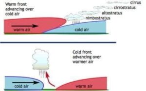
Fronts – What exactly are fronts? These are boundaries between large air masses of different temperatures. These are represented on weather maps by colored lines – blue =cold, red=warm. A cold front is a high density air mass which moves towards and under a warm air mass. The warm air mass is pushed upward at a sharp angle causing moisture to condense rapidly. Heavy precipitation is often the end result. A warm front mass of air moves towards and passes over a dense cold air mass at a moderate angle, usually resulting in light perception.


Pressures – There are two different types, a high and low.

When forecasters say a low pressure area or storm is moving toward your region, this usually means cloudy weather and precipitation are on the way Low pressure systems have different intensities with some producing a gentle rain while others produce hurricane force winds and a massive deluge. The centers of all storms are areas of low air pressure. Air rises near low pressure areas. As air rises, it cools and often condenses into clouds and precipitation. If the low pressure area is the center of a Northern Hemisphere extratropical storm, a steady rain or snow can fall to the north of the warm front as warm moist air from the south rises up and over the cold air ahead of the warm front. Showers and thunderstorms often fire up ahead of the cold front in the warm, unstable air. Usually, showers and thunderstorms ahead of the cold front don’t last long as the precipitation is ahead of the warm front. Due to the counterclockwise circulation around low pressure areas in the Northern Hemisphere, cold air will likely be found to the north and west of low pressure areas while warm air is most often found to the south and east of low pressure areas. Often, you hear a weather forecaster say that an area of high pressure will dominate the weather. This usually means your region has several partly to mostly sunny days in store with little or no precipitation. Air tends to sink near high-pressure centers, which inhibits precipitation and cloud formation. This is why high-pressure systems tend to bring bright, sunny days with calm weather. Air flows clockwise around a high-pressure system in the northern hemisphere. As a result, regions to the east of a high-pressure center often have northerly winds bringing in relatively cold air while regions to the west have southerly winds bringing in relatively warm air. Sometimes, high-pressure systems stall over a particular region for long periods of time and bring several days of sunny, calm weather with little or no precipitation. High pressure systems usually form where the air converges aloft. As the air converges in the upper-levels of the atmosphere, it forms an area of higher pressure and is forced to sink. The sinking air spirals outward, clockwise in the Northern Hemisphere, counterclockwise south of the Equator.

Winds on the Great Lakes – On this map, the wind is measured with the use of barbs. A short barb is 5 knots, a long barb, 10 knots. If no barb and just a circle present, winds are calm. Wind barbs point in the direction “from†which the wind is blowing. On this particular map, the majority of wind is coming from a western direction at a speed of around 15 knots.
Isobars –These provide indication on the amount of wind to be expected.

Isobars are lines that connect points of equal atmospheric pressure on weather maps. Isobars are similar to height lines on a geographical map, and they are drawn so that they can never cross each other. Meteorologists use isobars on weather maps to depict atmospheric pressure changes over an area and to make predictions concerning wind flow. The term “isobar” originates from the Greek, isos (equal) and baros (weight). Wind is a direct consequence of air pressure differences. The greater the pressure contrast over an area, the shorter the distance between isobars on a weather map depicting the area. Wind blows from areas of high to low pressure. The greater the contrast in pressure difference between two areas, the faster the wind will blow, so closer isobars on a weather map predict higher velocity winds.
Precipitation – (non winter months will be described) range from light green to purple – describes the intensity of the precipitation; light green relates to light rain – purple relates to intense storms
Some basic weather predictions are from the clouds which are present. Each type of cloud pattern provides indication of future conditions in the hours or days ahead. I will mention a few simple examples.
Good clouds vs the Bad clouds

Let’s look at a perfectly clear day. Little to no clouds in the sky and sunny. This would indicate no change of conditions. On a partly cloudy, or partly sunny day, the clouds present are loose, fluffy, cotton ball clouds, which would indicate fair weather. These are called, Cumulus. These are formed usually under 10,000 feet , or low clouds. If these clouds bunch up, form firm edges with definite shapes, this would indicate heavy showers will soon arrive.


One of the higher clouds (over 20,000 feet) is called Cirrocumulus. They look like rippled sand or fish scales. They are nicknamed ‘Mackerel skyâ€, they are considered an omen of bad weather (usually rain).


A Cirrus cloud is a high, wispy white cloud composed of ice crystals – which indicate short term good weather – often called, “mares tailsâ€. These commonly bring winds the following day.


Some towering clouds which swell up to 60,000 feet – one called a swelling Cumulus – These are flat bottomed which have a growing, cauliflower-like towers, they often form Mid-day and precede the next type of cloud which will be covered, the Cumulonimbus.


The Cumulonimbus are towering storm clouds, which bring rain, sleet, hail, thunder, lighting and tornadoes. The top of the cloud is usually anvil-shaped. One should really pay attention to these and seek shelter when needed.
.

Fog – Fog can be considered a cloud at ground level. The processes forming it, however, are usually different from those that form clouds. Like clouds, fog is made up of condensed water droplets which are the result of the air being cooled to the point (actually, the dew point) where it can no longer hold all of the water vapor it contains.Â


Now, there are some dangers in which we should be aware-Â
Thunderstorms. At no time should a paddlers be on the water during a storm. If a storm arrives suddenly, get off the water and seek shelter. Thunderstorms occur when large air masses rise quickly into the atmosphere, forming huge cumulonimbus clouds. Severe air currents inside the clouds cause water droplets and ice crystals to crash into one another, the friction between the particles creates static electricity within the cloud. Over time, opposite charges build between the top and bottom of the cloud, and the bottom of the cloud and the earth. When these opposing charges become intense, a gigantic spark occurs (lighting).
Winds – another potential danger to the paddlers. Winds is caused when air moves from an area of high pressure to one of low pressure. The greater the difference between the areas, the stronger the wind. Gentle breezes are usually dealt with, however, strong gusts and/or excessive winds may cause one to be pushed off course and into dangerous rocks or obstructions, and be exhausting to the paddlers. There are a few types of winds:
Head winds – these are winds coming directly at the paddlers – which equals resistance during a paddle
Tail winds – these are directly behind the paddlers, makes it easier to paddle.
Cross winds – these will come from either side and push one off course.
Fog– Usually is caused by warm air moving and cooling over water. This can disorientate the paddlers, obstruct recognition of coastal features, and placing the paddlers in harms way with larger vessels. Best to paddle close to shore , close to your paddle partner, turn on lights, and use either a fog horn, or a whistle to announce your location to other boaters – avoiding near misses. When paddling with a smaller group and seeking out a solo paddler, one can form a line. The basic principle with this: one paddler paddles near shore, the next in line paddles just far enough either to the left or right to the shoreline paddler to see them, the next in line continues this positioning. (much like walking hand in hand).
Forecast and Reports –
In order for a safe paddle, know what the forecast is for the venue. Obtain the local weather report by either TV, radio, or the paper. While on the water, tune into a 24 hour NOAA weather report on a VHF radio. Or, if you do not have one, listen to the weather station on the radio. There are smart phone apps in which may be helpful to plan the day. NOAA web page has information for digital graphic water conditions and advisories, which include water temp, wind speed and direction, and wave heights
Weather Lore:
A Logger was preparing for a fall town meeting and called the National Weather Service (NWS) to find out about the weather. He was told that the winter was going to be cold, so he included this in his report to the counsel. The logger began gathering fire wood.
The logger called back a couple of weeks later to make sure that his camp was prepared and was told that it looked like it was going to be a harder winter than usual. He passed the word to his people to gather more wood.
A couple of weeks later, he was finalizing his winter plans and called the NWS again, and was told that it was going to be terrible. When he asked why they thought that, the man told him, “We’re not exactly sure, but the local logging camp is gathering wood like crazy!â€
The moral of the story? Don’t depend solely on somebody else to make your preparations! We have a few signs that can help you determine what the weather will be, and here they are:
Here are some sayings which may hold some truth:
When morning fog clears quickly away, expect a sunny day.
A sun-shiny shower, won’t last half an hour
Mackerel sky and mares tails make tall ships carry low sails. (certain clouds are often followed by high winds) As mentioned in explanation of types of clouds.
Christmas day on the balcony means Easter in the embers
Squirrels tail fluffy, winter will be blustery
Onion’s skin very thin, mild winter coming in. onions skin thick and tough, coming winter cold and rough.
Red Skies and Rainbows
You’ve probably heard the old sailors’ poem of “red skies at night, sailors delight; red skies in morning, sailors take warning.†This is actually a good indicator of what’s coming. If the sunset is beautifully pink, the sun is shining on dust particles being pushed by a high-pressure system, which brings warm, dry air. If the sunrise is red, a low-pressure system is often pushing moisture toward you. Not always accurate but something to pay attention to.

Rainbows follow the same pattern: if you see one in the eastern sky in the morning, there’s a good chance that you’re going to get rain. The rainbow is caused by the sun reflecting off of moisture and most storms in the northern hemisphere move east to west.
Squirrels and Birds
Are the squirrels having knock-down drag-outs in your yard over the dwindling supply of nuts? Are the birds attacking your feeders like they haven’t eaten in weeks? If so, there’s a good chance that a substantial storm is on the way. This is another great way to read nature’s signs to predict weather. Similarly, if you notice that birds are migrating early, you should follow their lead and be ready to bunk in early for winter too. Winter is coming early.


In the shorter term, if birds are flying high, you’re probably going to have a good couple of days. When the pressure drops, indicating an upcoming storm, it hurts birds’ ears and they fly lower to alleviate that. Animals sense changes in barometric pressure well in advance of weather events so pay attention.
Look to the Moon: If the moon has a circle (halo) around it, this is almost a sure sign that there’s inclement weather heading your way in the next 3 days or so.The closer the ring is to the moon, the sooner participation will occur. If it’s clear and bright, you may also be getting some moisture because a low-pressure system has moved in and cleared the dust from the air.


If the moon has an orange hue or pale, there’s dust in the air so you’re probably going to see some good weather the next day.
Watch Your Cat Take a Bath
Cats typically lick their paws and swipe their eyes but they usually leave their ears alone. They’re finicky like that. However, cats’ ears are particularly sensitive to changes in pressure so if he’s swiping his ears, there’s a good chance that bad weather is imminent in the next couple of days.

Herd Animals Unite
Animals such as cows, deer and horses are pretty good at telling you bad weather is coming if you just pay attention. Cows in particular are good at predicting drought; you’ll notice a drop in fertility rate if the next year is going to be tough. In the short term, watch for herd animals to group together, typically facing the same direction. If you see that, a storm is likely near, they also tend to lay down just before a rain. .

Also, horses and cows have ears that are sensitive, similar to a cat. If you notice them trying to scratch an ear with a hoof more often than usual, the pressure may be changing and bring a change in weather with it.
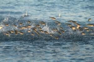
Good Fishing, Bad Storm
If you have an absolutely spectacular fishing day, where your line gets hit every time it hits the water, you may want to plan your fish bake for inside instead of out. Fish are great at sensing changes in pressure and will feed heavily before a storm so that they can go deep to weather it out.
Watch Your Campfire for Rain
If the smoke from your fire rises without any significant swirls, you’re probably in for good weather the next day. If the smoke blows back down or escapes in swirls, there’s low pressure in effect, which means bad weather is imminent.

Get to know your local environment; when you do, you’ll start noticing patterns in the local animals and plants that are linked to the weather. Being able to read nature’s signs to predict weather can be an invaluable skill that may very well save your life, or at least your paddle trip! Remember, you aren’t going to melt if you get a little rain on ya, no matter how sweet you think you are. Enjoy!

For the Paddler Within….