Kayak Chart Reading: Why do some lights flash at night?

Seasoned kayakers will tell you, paddling in low to no-light environment can be challenging. While on the water at night, shoreline object recognition is not as vibrant as it usually is during the day. A kayaker should have the ability to navigate safely during their time on the water. Much like reading a street map while driving, paddlers can use a navigation chart to reach their destination. In this post, we are going to explore land-based lit objects, and how they are useful.
Why use navigation charts versus ordinary land-based maps? Well, there are unique features which are on navigation charts which do not show up on land-based maps. These features represented on a chart have special markers, indicators, or initials. There are many symbols which are on these navigation charts – understanding all of them can be a challenge. Luckily, there is an “answer key” one may reference to gain incite as to their meaning. This would be US Chart #1 – Symbols, Abbreviations and Terms used on Paper and Electronic Navigational Charts. Each large body of water has a navigation chart, which can be either downloaded, or one may obtain a paper-based copy. Paddlers will usually only use a segment of the chart, plot their destination, and place it on their front deck for easy access.
Let’s look at a couple of harbor entry markers. From the chart, these are markings specific to that feature: The purple mark denotes it is lit object, the first group of letters describes what it really is (or where it may be located), the next line states what it does, and some additional information about it.
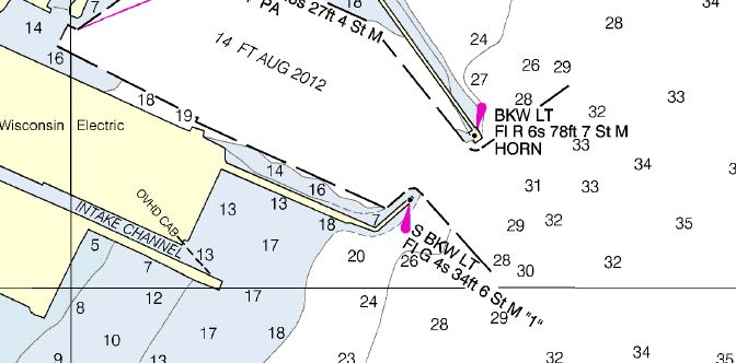 Here is a local harbor opening with two light sources, denoted by the purple mark, pointing to the black circle.
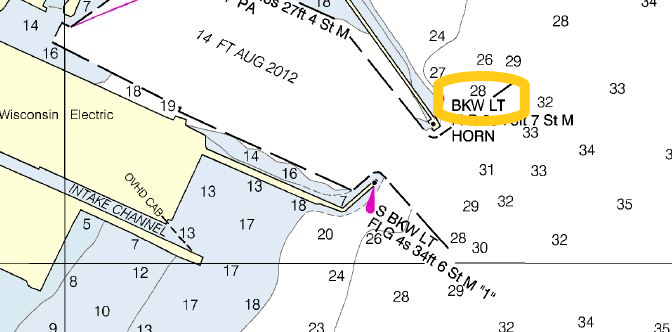 Let’s focus on the top one. BKW stands for Break Wall, LT stands for light. It will provide a location of where this structure is located.
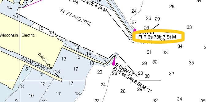 Fl stands for Flashing. R is Red. Then how many seconds between flashes (6s). 78ft stands for how tall the object is. 7 St M is telling you this light source can be seen from 7 Nautical Miles (on a really clear night).
Let’s match what is on the chart to what one actually will see while on the water. Note how the color of the lights, and the delay of the flash of light matches perfectly with the information provided? Can you identify which one is north of the other?
Kayakers who explore the waterways should have at least a basic understanding how to read a chart. Some of these include: orientation, knowing where you want to go, what land marks one can use to plot their course, and what potential hazards may be along the way. Think of these as road signs we encounter daily when we drive – they are informational tools. Since there are numerous icons, and symbols listed contained within the Chart #1 – it may take a while to fully understand these, or put them in practice. With time, and incorporating navigation charts into your paddle trips will only increase your awareness and expertise.